
Ruten defineres som krevende
Ruter som defineres som krevende egner seg for personer med erfaring i krevevende partier.Tid
6:00 timer
Lengde
318 km

Popularitet
7.4 av 10
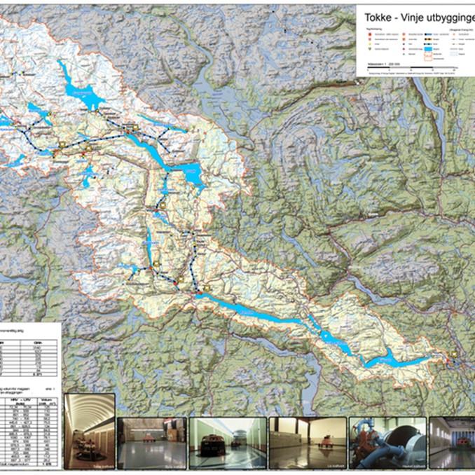
Følg kartet og les i tillegg beskrivelsen og avsnitta om adkomst til kvart av anlegga. God tur og ta gjerne ein god kopp kaffe på vegen.
Lokale bensinstasjoner som leverer 98 oktan
Sjekk ut den norskutviklede appen Refuel levert av AMCAR i samarbeid med High Octane AS for iOS og Android telefoner.
GENERELT OM TOKKEUTBYGGINGA
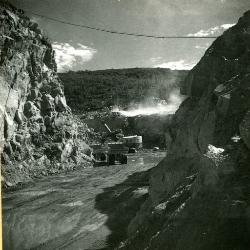
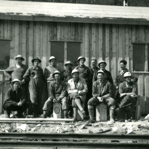
Kjerna i Tokkeutbygginga var idéen om å nytte fallet på 600 m mellom innsjøene Totak i Vinje og Bandak i Tokke kommune. Men både ovanfor og nedanfor Totak var det innsjøar, elvar og fossar som egna seg til oppdemming som magasin i eit større reguleringsområde. I 1956 gjekk startskotet til det som då var Nord-Europas største kraftutbyggingsprosjekt.
Med pengar frå Verdsbanken, staten, fylket og nokre kommunar starta ein anleggsperiode som varte til 1969 (sidan forlenga til 1979) som snudde opp-ned på tilværet og økonomien i øvre Telemark. 7 kraftstasjonar og 37 damanlegg blei bygd. I 1987 kom enda eit kraftverk (Hogga) lenger nede i Telemarkskanalen.
Tokke reguleringsområde omfattar eit nedbørsfelt på heile 3104 kvadratkilometer. Det tyder at så mykje som 3,3 milliardar kubikkmeter med regnvatn årleg renn inn i vassdraget og produserer straum fleire gonger på vegen ned vassdraget. Totalt leverer Tokkesystemet 4,4 TWh (terrawatt-timer) i året, nok til å forsyne over 200.000 husstandar med straum! Statkraft administrerer heile anlegget.
VEST-TELEMARK Museum, Eidsborg
I dette museet finst ei eiga utstilling som fortel historia bak Tokkeutbygginga med film, animasjon og bilete. Her er òg ein installasjon som visar korleis magasin, dammar, røyrgater og kraftverk hengar saman og blir styrt for å oppnå maksimalt utbytte av regnvatnet over det enorme området.
Dette skapar «batteri-effekten» der vatn kan bli lagra i fleire år til seinare bruk. Dei store elvane på Austlandet har ikkje denne moglegheita, og kan berre produsere straum medan elva renner.
På førespurnad tilbyr museet omvising i denne delen av utstillinga, men dei øvrige utstillingane er òg verd å få med seg før ein kastar seg i bilen og finn fram kartet. Eidsborg stavkyrkje er ei perle her i Vest-Telemark og ligg inne på museumsområdet.
Bestilling av tur, omvising og egna kart gjerast i resepsjonen på Straand Hotel. Her vil ein òg få tips om lunsj-stopp og andre attraksjonar langs vegen.
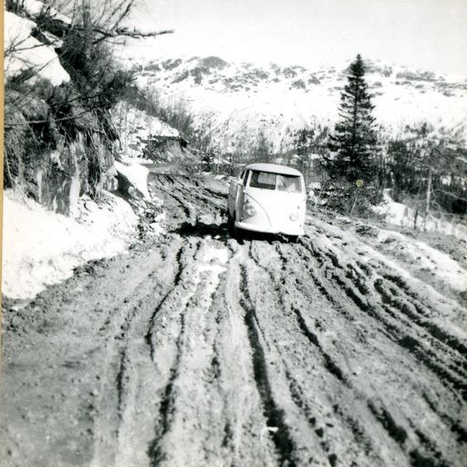
Ein må rekne ein rundtur på ca 5-5,5 timer. Ein stor del av strekninga er på høgfjellet og kan by på ulikt vêr… kanskje ta med ei varm jakke.
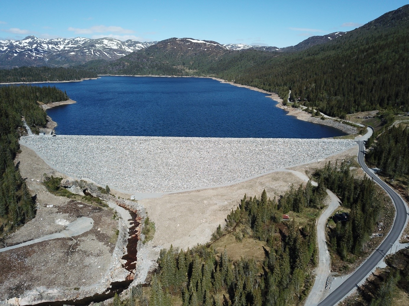
1 BOTNEDALSDAMMEN
Botn(e)dalen i Mo – i dag Tokke kommune – har frå gamalt av vore ein ferdselsveg mellom øvre Telemark og Setesdalen, og vidare til Vestlandet. Her var det mykje handel og kulturutveksling, og eldgamle busettingar. Her blei det drive med utvinning av jarn, og reinen har eit eige trekkområde her (Setesdal-Austhei).
Fram til midten av 1600-talet skal det ha vore ei eiga bygd i Botnedalen. Det skal òg ha stått ei stavkyrkje her. Men etter «hardæva», ei klimakrise utløyst av fleire vulkanutbrot i Stillehavet mellom 1639 og 1644, blei dalen fråflytta. Kyrkja blei rive, og i dag er berre kyrkjedøra bevart. Ein rekonstruksjon av døra kan sjåast på Vest-Telemark Museum i Eidsborg.
På 1800-talet var Botnedalen i gamle «Moe Sogn i Thellemarken» kjend for å være særs idyllisk. For eksempel kalla presten Simon Olaus Wolff den for «en vakker Dal» og «en fiin Møe [jomfru] i en sværdrunet [sverdbiten] Kjæmpes Arm» [Brudstykker af en Thellemarksvandring i sommeren 1822].
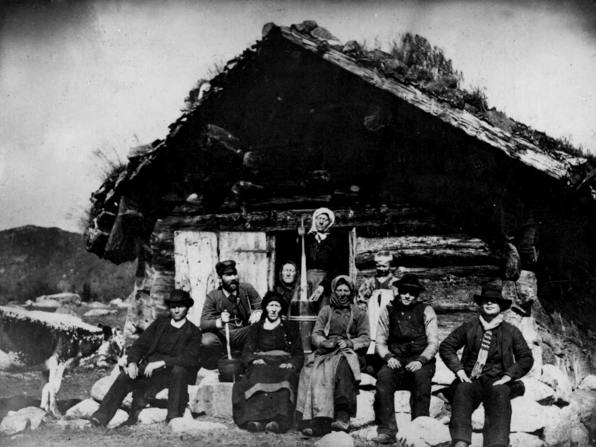
I Botnedalen var det mange støylar. Ein av dei var Låmyrstaulen som høyrde til prestegarden i Mo. På eit kjent fotografi frå slutten av 1800-talet kan me sjå Torbjørg Ripilen som arbeidde på prestegarden og støylen i periodar. Ho var ein av dei som song mellomalderballaden Draumkvedet for folkeminnegranskarane Moltke Moe og Sophus Bugge i 1890.
Då Botnedalsdammen stod ferdig i 1969, som del av den store Tokke-kraftverkutbygginga, blei store delar av Botnedalen sett under vatn.
Slike neddemmingar, som det var fleire av, utløyste dei første offentlege disputtane kring natur- og kulturvern i Noreg på 1960-talet. Biletkunstnaren Dyre Vaa t.d. stilte spørsmål ved om det var rett å demme ned verdfull natur og eldgamle kulturminne.
Men det var òg dei som forsvarte utbygginga. Forfattaren Tarjei Vesaas skreiv alt i 1958:
«Ingen har rett til å døme sine medmenneske til å bu i museum. Det er vakkert med gamle hus, men det er annleis for ei husmor som skal arbeide der. Der bryt teknikken inn som ein velsigning. Slett ikkje alt ved det gamle er godt fordi det er gamalt…»
I dag nyttast vatnet frå Botnedalsvatnet, med tilsig frå Strandstøylsdalsvatnet, til kraftproduksjon ved Byrte kraftverk, og fleire gonger på veg ned i Telemarksvassdraget. Effekten på turbinen i Byrte er 25 MW, og årsproduksjonen ligg på 112 Gwh.
Framkomst: Bildet frå Botnedalen dam (bilete) ligg i sørenden av Botnedalsmagasinet i Tokke kommune. Dammen ligg 10 -12 km vestover frå Dalen, og delar av vegen er bomveg med kontantkasse eller Vipps. Vegen består av strekninger med asfalt og grus. Bomvegane til Songa og Botnedalen er blindvegar, utan moglegheit for gjennomkøyring.
2 VENEMO
Venemodammen er ein av dei mange dammane i den store Tokkeutbygginga og blei ferdig i 1963. Den demmer opp vatnet i innsjøen Venemo som kjem heilt frå Bordalsvatnet 200 m lengre oppe.
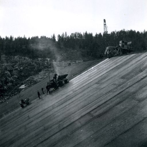
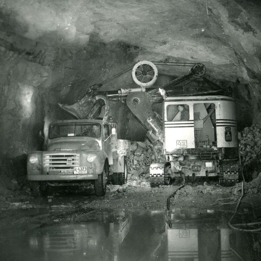
Venemodammen er den første fyllingsdammen i Noreg som er tetta med asfaltbetong. På fotografia til NVE sin fotograf Jostein Granlid kan ein sjå korleis det gjekk føre seg.
Dammen har eit unikt ringforma overløp som står opp frå botnen og kan vere eit spektakulært syn ved høg vassføring. Overløpet er av typen «Morning Glory Spillway» som finst ved eit utval kjende demningar verda over.
Frå Venemodammen er det sprengt ut ein tunnel som fører vatnet vidare til Totak og Våmarvatn som er inntaksmagasin til Vinje kraftverk, det nest største etter Tokke kraftverk i utbygginga, med utløp til Vinjevatnet. Kraftverket blei sett i drift i 1964 og produserer 1017 Gwh med ein turbineffekt på 300 MW. Dei tre turbinane på 100 MW har kvar sin trykksjakt med ein fall på 225 m.
Framkomst: Venemo dam (flyfoto) ligg 3-4 km frå Haukeli på FV 362 på veg mot Rauland.
3 SONGADAMMEN
Songadammen sto ferdig i 1962. Det oppdemma Songavatnet er sett saman av opphavleg 11 mindre innsjøar. To dammar held vatnet på plass: Trolldalsdammen og hovuddammen (Songadammen) her ved Naustnuten. Songadammen er over 1 km lang, 37 m høg og var lenge den største steinfyllingsdammen i Noreg. Dammen tok fire år å bygge og er eit imponerande syn den dag i dag. Overløpet går via elva Songa til innsjøen Totak.
Vatnet frå Songadammen bidreg til kraftproduksjon ved Songa kraftverk som opna i november 1964. Det får vatn gjennom tunnelar frå tre ulike innsjøar: Bitdalsvatnet, Kvikkevatnet og Songavatnet. Trykksjakta frå Songavatnet ned til kraftverket har ein fall på 287 m og har utløp i Totak. Turbinen var den største i si tid og leverer åleine 140 MW. Gjennomsnittleg årsproduksjon er 575 Gwh.
Framkomst: Songadammen (bilete) har avkøyring ca. 2 km vidare frå Venemo dam. Denne vegen er 6-7 km lang og ein kombinasjon av asfalt og grus. Dette er bomveg med elektronisk registrering.
4 HAUKELI KRAFTVERK
Haukeli var det første kraftverket i Tokkeutbygginga og blei opna alt i 1957. Det ligg i elva Vai, mellom Vatjønn og Flothylåi, og har Langeidvatn som reguleringsmagasin. I tillegg får kraftverket vatn frå Gurivatn. Tunnelen frå Vatjønn er 215 m lang og har ein fall på 268 m.
Kraftverket blei bygd med tanke på å forsyne anleggsarbeidet i Tokkeutbygginga med straum, og planen var å rive det etter anleggsperioden. Men Haukeli forblei i drift i heile 55 år før det blei erstatta med eit nytt kraftverk i 2013. I dag yter det kring 5 MW og er det minste i Tokkesystemet, med ein årsproduksjon på 38 GWh.
Framkomst: Haukeli kraftverk (bilete) ligg ca. 500 m vest for elva i Haukeli sentrum. Tilkomst via bru i krysset til R9.
Support
Dette kommer først og fremst an på om du har montert en GPS, navigerer etter App på mobiltelefonen eller foretrekker papirutskrift. Her beskriver vi de vanligste arbeidsflytene:
Mange av rutene på Hubriding bruker appen Ride with GPS for ruteplanlegging og navigering av rutene. Denne kan du laste ned i gratisversjon eller betale for utvidet bruk. Trykk på lenken Send to Device på kartet på denne siden, når appen har startet og du ser aktuell rute trykker du Navigate og så er det bare å følge ruta.
Hubriding betyr at du med base på et av De Historiske hotell, velger blant mange definerte kjøreruter som ligger i omlandet til hotellet. Rutene vi tilbyr går i noe av Norges aller beste terreng og omfatter titusenvis av svinger, spektakulære fjelloverganger, asfalt, grus, herlige naturopplevelser og muligheten til å spise godt ved lokale etablissementer. I rutene har vi lagt inn severdigheter og spisesteder du kan besøke. Du vil kunne velge mellom en rekke ruter og rutekombinasjoner som gjør det mulig å velge dagsetapper med varierende lengde og vanskelighetsgrad. Konseptet er utviklet av Straand Hotel i Vrådal sammen med Norges fremste MC-entusiaster